
The Kuna Yala: San Blas Islands
- Tom

- Mar 24, 2023
- 4 min read
Updated: Sep 20, 2023

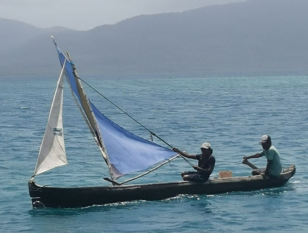
The San Blas Islands are the home of the Kuna Yala Indians. Although part of Panama, the Indians are afforded certain autonomy from the central administration and, for many aspects, practise self government. A practical example is that a Panama cruising permit does not cover the full Panamanian coastline. A separate cruising permit is needed for this area with the revenue going directly to the Indians. There are estimated to be around 300,000 inhabitants spread over the hundreds of islands. Each small area has its 'Sahila' or leader. They still use dugout canoes (both paddle and sail powered) and rely heavily on fishing and agriculture.
The area itself is beautiful, maybe even a paradise. But big differences exist between the eastern end compared to the west near Porvenir. Further east the anchorages are characterised by mangroves, mud and murky waters. There are few cruisers, and the Kuna Yala culture is richer. We only got as far as Snug harbour but friends who explored the eastern end extensively, told us that, in the eastern end, there is more effort to keep their traditions alive.
Further west, the Kuna people have made trading with cruisers an important part of their economy. They ask local mooring fees, sell fish, lobster, octopus, vegetables and molas (fabric based artwork).

And the reason the cruisers tend to stick to the west is that the anchorages are 'picture perfect' with tropical islands laced with palm trees and lines with beautiful beaches.

The one common factor between the whole area is the preponderous of reefs, inaccurate charts and navigational hazards everywhere - all unmarked (we found a rock not even on the Bauhaus charts). It is imperative to get into an anchorage whilst the sun is still high and visibility is good. There is no other way to see the dangers which may be lurking just below the surface.
The eastern end is also more accessible, being only 40nm from Linton Bay. During our stay there we met people who had spent six months in the San Blas islands, periodically returning to Linton Bay for fuel, provisions (e.g. meat), to collect or drop off new crew/guests or to effect repairs. Thanks to the five weeks we lost repairing our solar arch, our visit was more fleeting. Having been measured in Colon, our transit was scheduled for 14 days later. We needed 2 days to get there and back, leaving just 10 days to cruise the San Blas.
After Linton Bay, our first stop was Chicheme, close to Porvenir. There was little wind and, with the aforementioned 16.00 arrival deadline, we ended up motor/sailing more than half of it. The entrance between two reefs is no more than 30m wide but, once inside, you are surrounded by islands or reefs for 300 degrees, so it was like anchoring in a millpond. Like most of the anchorages, it was so flat that Annick was able to do yoga on the aft deck. Very impressive. Of course, we were not the only cruiser there.

The next morning we headed for Cayos de Hollandes (Holland Keys). Again, wind was light but it was only 20nm so we managed it under sail. This was another beautiful location with another relatively tricky entrance to work your way in to the 'Swimming Pool'. Some of the locals had established a small, outdoor restaurant which is highly recommended. You could not ask for a better view

We wanted to get as far east as possible with our limited time. Isla de Pinos was our goal. But again, the wind was light and we even had to use the engine to get to Snug harbour. This was the first anchorage where we were the only boat there. The bay was huge. We felt quite isolated. Slightly further south there used to be coal bunkering (storage of coal and refueling station).
After Snug harbour we decided to head back west. We probably could have reached Isla de Pinos but it would have been a rush and we wanted to be sure we had enough time to complete preparations for the canal crossing. In any case, there are literally hundreds of beautiful anchorages to explore further west.
Our first stop was Iguana Island. It was a little exposed but the winds had been light so we did not expect any issues. Cue wind! By 15.00 we had 20-25 knots and the boat was rolling enough to tell us we had to move. Fortunately we only had 3nm to go to Sabodupored, probably my favourite stop.

After that we found another lovely anchorage off Waisaladup (first photo) before visiting Green Island, famed for great snorkelling and lots of sharks!
The water was clear and so we also used the time to properly clean the hull, keel and rudder.

I last did this in Bonaire using scuba gear. The rules to get into Galapagos are very stringent with hefty fines if they find even one barnacle on the boat (invasive species). Now I had to do the same task but free diving. Swimming down 2m and holding your breath long enough to do some meaningful work is not obvious at my age. But, splitting the task into 6 one hour sessions spread over two days got the job done. Of course, the task will need to be repeated as we approach Galapagos. But at least I have convinced myself that I am able to do it.
We still have a few days left before heading back to Linton Bay to acquire Jerry cans, fill up gas botttles, re-fuel and pick up our line handler volunteers. the transit on March 31st is getting closer.


According to all the sailing blogs (inc https://www.superyachtgalapagos.live/services/cruising-entry-permits/) "All vessels [ entering the Galapagos] must have a fumigation and clean hull certification given in the last port." This article implies that you intend to do the hull clearning yourself. If so how will you pick up a certificate - or alternatively do you not really need one?